


Where on Earth are you?
How do astronomers and others express exactly where everything is on Earth?
Why is knowing your latitude and longitude co-ordinates so important?
![]() If you have ClickView, watch the whole episode here.
If you have ClickView, watch the whole episode here.
 The STAR LAWS Episode IV Question Sheet for Students:
![]() The PDF version.
The PDF version. ![]()
Google The Google Doc version. Google
![]() The Microsoft Word version.
The Microsoft Word version.![]()
A short excerpt followed by a short trailer.
The Transcript:

The word astronomy comes from the Greek words astron which means star and nomos which means law. Astron nomy therefore translates literally as STAR LAWS. Astronomy is the study of the laws of nature that govern how stars and other bodies in space appear to move across the sky, how they form, and how they change over time.
In this episode, we’re going to look at the co-ordinate system that astronomers and others use to describe the position of any place on Earth with complete accuracy.
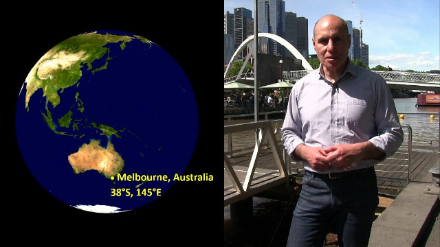
Hi Everyone, it’s Spiro here. In this episode of the Star Laws series, we’re going to look at the giant, world-wide grid system that scientists, astronomers, engineers, airline pilots, and lots of others use to express exactly where they are on Earth. The system uses what are called lines of latitude and lines of longitude.
Right now, I’m in Melbourne, Australia, which has a latitude of 38°S and a longitude of 145°E. What do these numbers (or what we call co-ordinates) mean? Well, by the end of this lesson you’ll know exactly they mean. Let’s begin.
When astronomers build gigantic telescopes to observe and to study stars, planets, and other objects in space, they need to know exactly where they are on Earth. This is because their location will affect the direction that they need to point their telescopes in to see what they want to see.

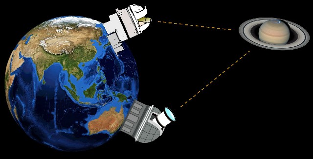
If astronomers want to, say, observe Saturn, they have to tilt their telescopes at a precise angle and in the exact direction that they need. Computer programs control the machinery that moves a huge telescope around so that it points exactly in the desired direction and to do this accurately the telescope’s precise location has to be known. So, a system is needed to pinpoint exactly where something is on Earth.
Now one way of pinpointing a location is to use simple grids on a map. Tourist maps, like this one, mark places of interest to help tourists easily find them.

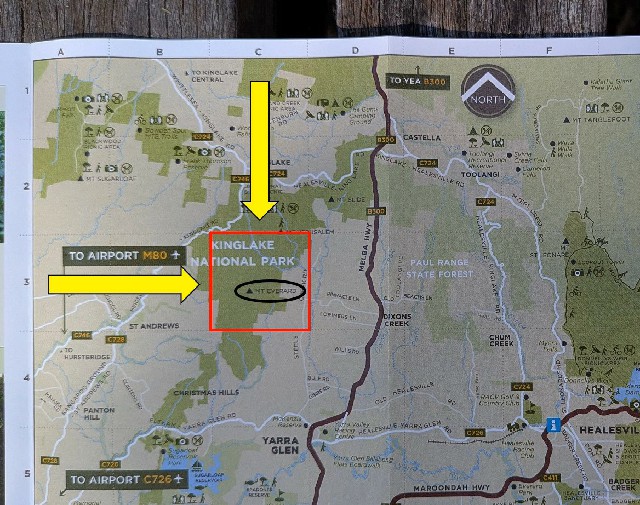
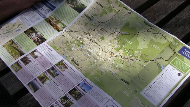
The maps usually have a row of letters along one side of the map and a row of numbers along the other. The grid lines (which are fairly faint) form what are called grid squares. For example, Mt Everard in Kinglake National Park is in grid square C3, while Mt Slide is in grid square D2. There’s a Star Wars reference right there! C-3PO and R2-D2! How ‘bout that!
Now, these grids work fine for these kinds of small-scale applications, but they don’t work for the whole Earth, because they just aren’t anywhere near precise enough.
Instead, we use a global co-ordinate system that uses lines of latitude and longitude. These lines allow us to express our location extremely accurately.
A place’s latitude is the angular distance it is from the equator measured from the centre of the Earth.
Lines of latitude, which are also called parallels, are marked on most globes. The equator has a latitude of 0°. This line is at a latitude of 15°S, this line is at a latitude of 30°S and so on.
The South Pole is at a latitude of 90°S.
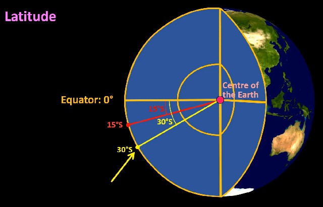
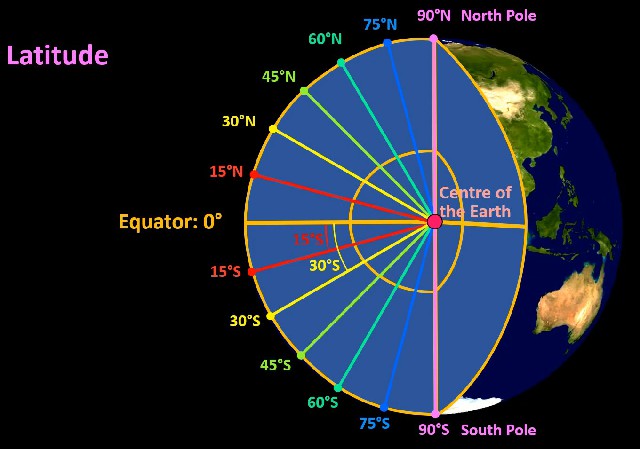
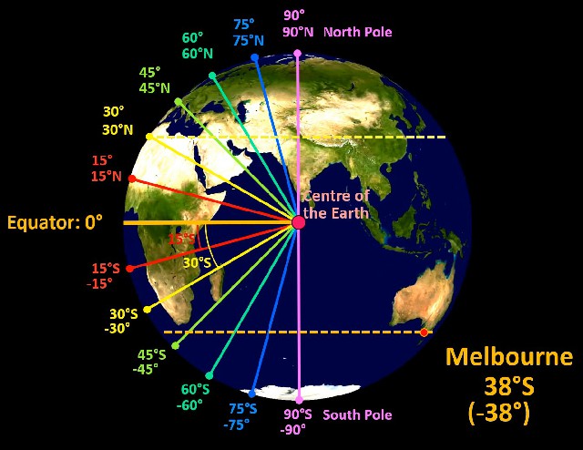
It’s probably easier to picture if we look side on and cut into the Earth. This point is the exact centre of the Earth. This point has a latitude of 15°S, since a line drawn from the centre of the Earth to this point is at an angle of 15° to the line that goes to the equator. 30°S is here, and so on until we get to the South Pole which, as I said, has a latitude of 90°S. This point has a latitude of 15°N and we can continue to the North Pole which has a latitude of 90°N. So, for example, everywhere along this line has a latitude of 30°N. Melbourne, the city I live in, is at a latitude of about 38°S.
 Quite often, north or south latitudes are expressed as positive or negative latitudes. So, a latitude of 38°S, for example, can also be written as a latitude of -38°.
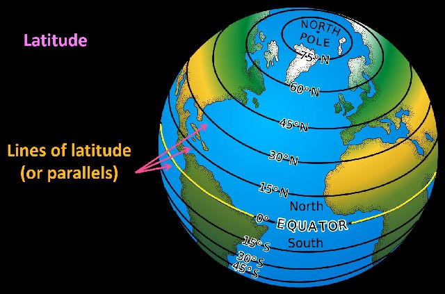
So, lines of latitude, which are also called parallels are used to express how far something is either north or south of the equator. The equator is the obvious reference line because it neatly divides the Earth into two hemispheres.
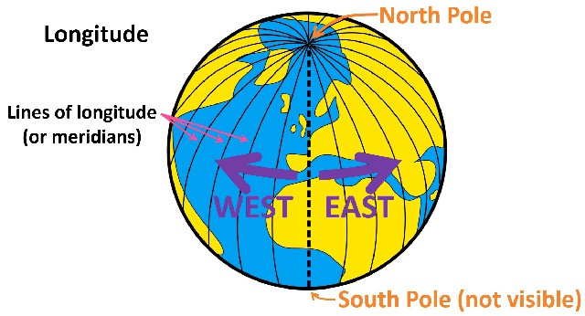 Let’s now look at longitude. A place’s longitude expresses how far west or east a location is. Lines of longitude, which are also called meridians, run from the North Pole to the South Pole. However, we need a reference line to be our 0° longitude line.
After the important work that the Royal Observatory Greenwich near London did in the 1700s and 1800s relating to astronomy and to the navigation of ships, the line of longitude (or the meridian) that runs through Greenwich was chosen as the reference line.
This meridian (that runs through Greenwich) is now called the Prime Meridian. An object’s longitude is the angular distance either west or east of this prime meridian.
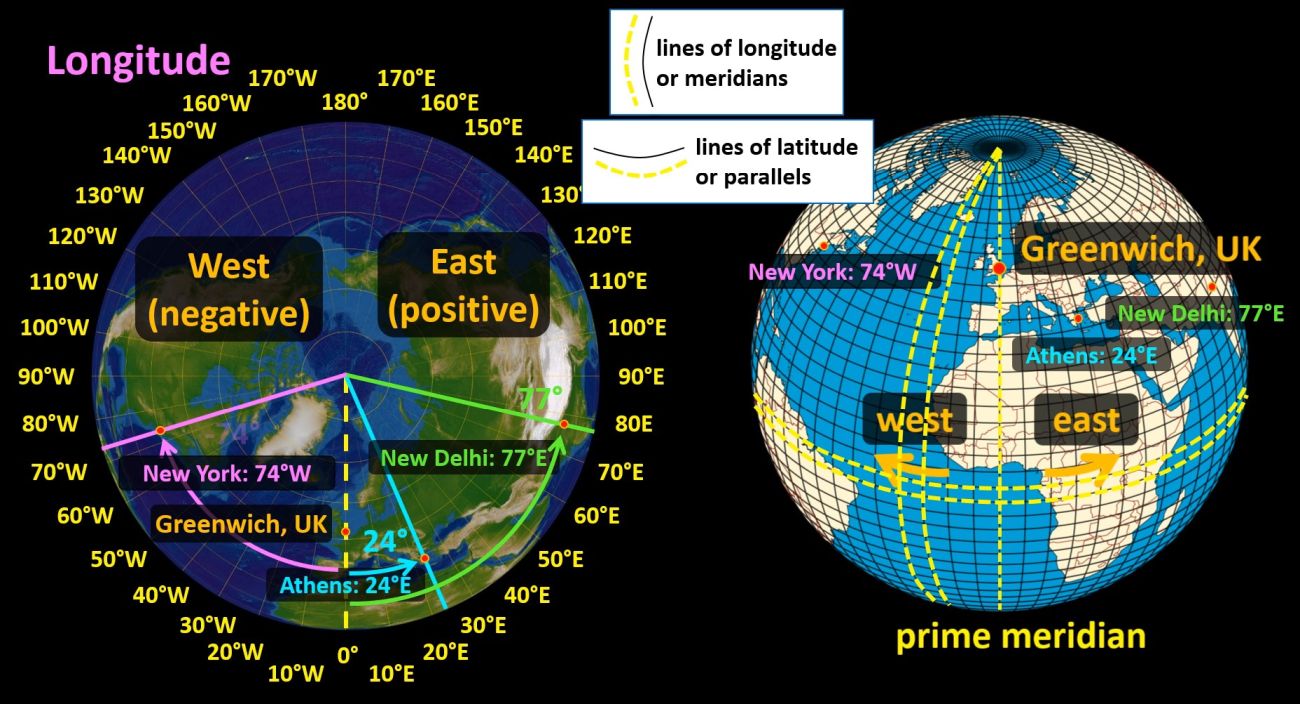
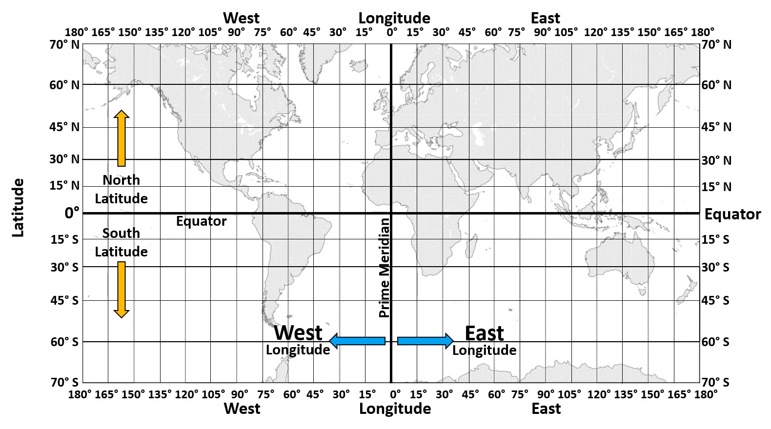
This map on the left shows what the Earth would look like from above the North Pole. Everywhere on the yellow dotted line, the prime meridian, has a longitude of 0°. We then have 10° West and 10° East, 20° West and 20° East, and so on until we get to 180°, which can be called 180° west or east. So, Athens, Greece, is at a longitude of about 24° east. New Delhi, India, is at a longitude of about 77° east, and New York, USA, is at a longitude of about 74° west. Remember, lines that runs from the North Pole to the South Pole are called either lines of longitude or meridians (and I’ll just mention again that lines of latitude are also called parallels).
Quite often, instead of stating a longitude co-ordinate as east or west, positive or negative values are given. East is positive and west is negative. So Athens and New Delhi have longitude co-ordinates of 24° and 77° respectively (which are both positive values), while New York is at a longitude of -74°.
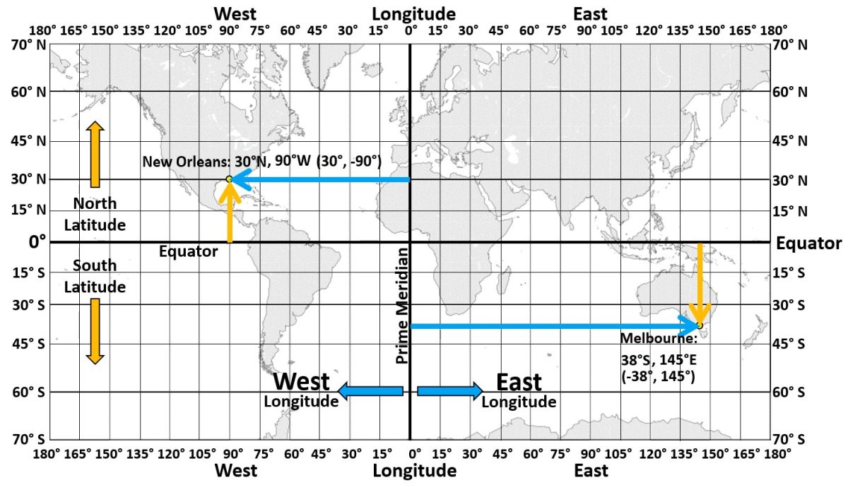
Many world maps include latitude and longitude lines. When giving a location’s co-ordinates, the latitude is given first. So, New Orleans is at a latitude of 30°N and at a longitude of 90°W. It’s a pretty easy one to figure out. These coordinates can also be written as 30°, -90°. Melbourne, my home city, is here at a latitude of 38°S, but if this was a test question and you wrote 37° or 39° South, I’d mark it as correct. Its longitude is 145°E. These figures can also be written as -38°, 145°.
 To help you remember which are lines of latitude and which are lines of longitude, it may be helpful to think of longitude lines as all being long. They all go from the North Pole to the South Pole so longitude lines are all long. Lines of latitude get smaller and smaller in length as they get closer and closer to the poles.
Now a lot of people sometimes get confused between lines of latitude and lines of longitude. Lines of latitude run east to west but they indicate position either north or south of the equator. You have to try to remember that. Lines of longitude, though, run north south but they indicate position west or east of the prime meridian.
So how much distance will you cover if you move 1 degree of latitude or 1 degree of longitude?
Let’s do some simple mathematics. The circumference of the Earth is about 40,000 km (about 25,000 miles). The Earth is actually slightly wider than it is tall so the length of the equator is actually about 40,075 km, while the length of the circumference from pole to pole is about 40,008 km. I’m going to round both of these down to 40,000 km.
We’ll start with latitude. To find what distance per degree of latitude is, we simply divide the total distance by the number of degrees. So let me slice the Earth on the left in half. The distance is 40,000 km and of course a full circle all the way round is 360°. So, 40,000 km / 360° = 111 km per degree of latitude. If you travel 111 km either north or south of where you are right now, you will have moved 1° of latitude. It wouldn’t matter where you started because every degree of latitude is the same.
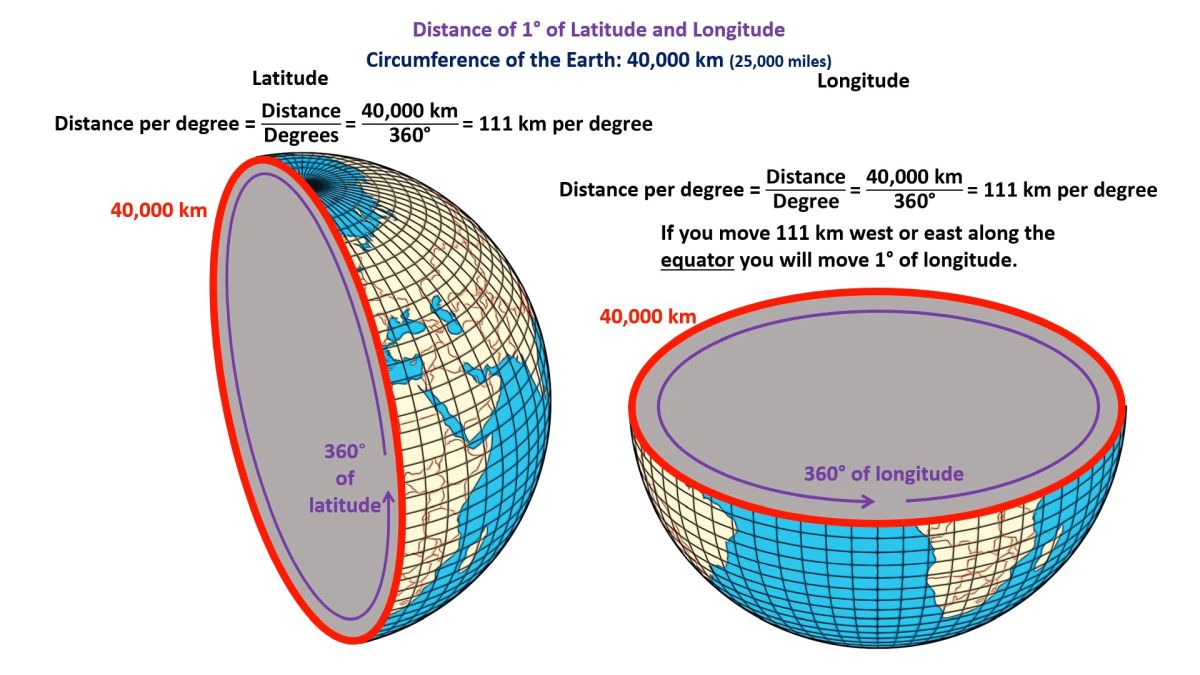
That’s not true, however, for longitude. The distance that you move east or west for every 1° of longitude changes depending on where you are. Let me slice this Earth on the right in half. At the equator, if you move east or west. it’s the same calculation as before. The equator has a circumference of 40,000 km and the full circle is 360°, so 40,000 km divided by 360° = 111 km per degree. If you move 111 km west or east along the equator you will move 1° of longitude. Now, this is only true at the equator. As you get closer to the poles, each degree becomes a smaller and small distance.
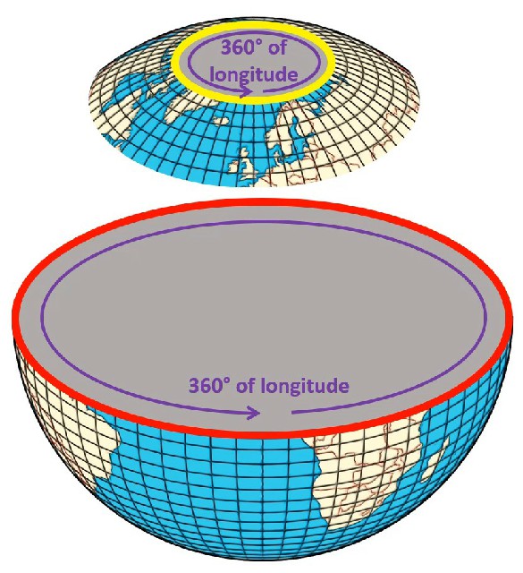 You can see here that a full 360° of longitude (west or east) at the equator is a much longer distance than a full 360° of longitude near the north pole. As you get further and further from the equator, the distance between each degree of longitude gets smaller and smaller because longitude lines get closer and closer.
Now throughout this lesson, I’ve been giving examples of latitude and longitude co-ordinates to the nearest degree. Since each degree can represent a distance of up to 111 km, that’s hardly pinpoint accuracy. However, latitude and longitude co-ordinates can be expressed with as many decimal places as our technology allows.
 If you go to Google Maps on a computer and click on a location, Google Maps uses 6 decimal places to express location co-ordinates which is accurate down to about the nearest 10 cm.
So how do they work that out? Well, it involves using our knowledge of star laws and of satellite technology, but we’ll talk about that in our next episode. Let me finish this episode by saying that where we are on Earth affects what stars we can see in the sky, how stars and planets appear to move across the sky, and a whole lot more. We’ll be coming back to latitude and longitude quite a few times throughout the Star Laws series. See you in the next episode!
CREDITS
Produced by Liacos Educational Media
Opening and end titles music by Humanoide_Media via Pixabay.
https://pixabay.com/users/12661853/?tab=music&order=latest&pagi=1
https://pixabay.com/music/main-title-star-wars-style-march-165111/
https://pixabay.com/music/main-title-invasion-march-star-wars-style-cinematic-music-219585/
Star-Wars-style opening crawl generated at the STAR WARS Intro Generator website. https://starwarsintrogenerator.com/