

Why does the Sun get higher in the sky in summer than it does in winter?
What angles are we actually talking about?
Do the angles change in different locations?
How can I find data for where I live?
A 2½-minute except followed by a short trailer.
 The STAR LAWS Episode VIII Question Sheet for Students:
![]() The PDF version.
The PDF version. ![]()
Google The Google Doc version. Google
![]() The Microsoft Word version.
The Microsoft Word version.![]()
![]() If you have ClickView, watch the whole episode here.
If you have ClickView, watch the whole episode here.
Coming soon also to Learn360, Classroom Video on Demand, and Safari Montage.
The Transcript:


The word astronomy comes from the Greek words astron which means star and nomos which means law. Astron nomy therefore translates literally as STAR LAWS. Astronomy is the study of the laws of nature that govern how stars and other bodies in space appear to move across the sky, how they form, and how they change over time.
In this episode, we’re going to explain why the Sun gets to a higher angle in the sky in summer than it does in winter….
Hi everyone, it’s Spiro here. Right now, it’s early morning and the sun is rising behind me in the eastern part of the sky.
The sun always rises in the eastern sky and gets higher and higher above the horizon until about midday, after which it gets lower and lower before setting in the western sky.
 If you look at the shadows cast over a whole day, they start by pointing westwards, since the sun is over in the East. They’re also long because the sun is not at a very high angle above the horizon. In the middle of the day, the sun gets to its highest angle above the horizon and so the length of the shadows are at their shortest. As the sun starts heading back towards the horizon in the west, the shadows get longer and point more and more towards the east.
Because of the tilt of the Earth, the path that the sun appears to take every day actually changes throughout the year.
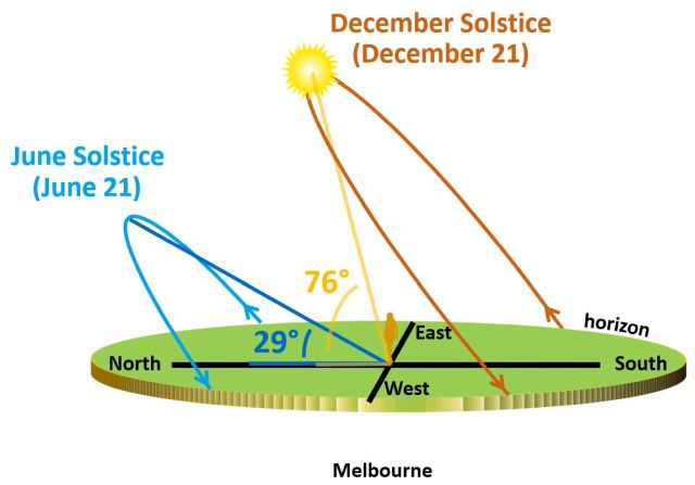 For example, in Melbourne, where I live, on the day of the June solstice, the sun rises north of east, gets to its highest angle of only 29° in the middle of the day and then sets again north of west. On the day of the December solstice, the Sun rises south of east, gets to its highest angle of 76° and then sets south of west.
Our knowledge of the paths the sun takes has helped us to build, for example, energy-efficient solar panels that are programmed to turn so that they can follow the sun as it moves across the sky, which maximizes their output. Astronomy (or STAR LAWS) isn’t just about what’s up in space, it’s also about us and about the Earth we live on.
So how and why does this variation of the Sun’s path occur? Well, over the next few lessons that’s what we’re going to explore. In this lesson, we’re going to look specifically at why the Sun reaches a higher angle in the sky in summer than it does in winter.
The time of day that the sun is at its highest point in the sky (let me freeze frame it) is called solar noon.
Solar noon doesn’t necessarily occur at 12 o’clock midday because it depends on where you are in the time zone you’re in.
 Here I’ve placed a marker on Sydney, in eastern NSW, and another marker on Mildura in western Victoria. Both locations are in the same time zone. Now as the Earth turns, Sydney gets solar noon first. You can tell it’s solar noon in Sydney because its marker’s shadow is at its shortest and the shadow is pointing directly towards the south. On the day of the December solstice, solar noon occurs in Sydney at about 12:48 pm. Mildura, though, doesn’t get solar noon until 1:24 pm, 36 minutes later, because it takes another 36 minutes for the Earth to spin around to the point where Mildura is in line with the sun. You can see that the Mildura marker’s shadow is now at its shortest and it’s the one pointing directly southwards.
Since accurate clocks were invented, we don’t usually notice when solar noon occurs of course, but it is still an important part of understanding how the sun moves across the sky.
 If you’re in the Southern Hemisphere, in a place like Melbourne where I am now, at solar noon, which, as I said, is when the sun is at its highest point in the sky, which is right now in fact, the sun will be directly North of where you’re standing and your shadow will be pointing directly south. That way is south. It’s the opposite in the Northern Hemisphere, where your shadow will be pointing north.


I can simulate the situation with my globe and my spotlight. In the morning the sun rises in the east. The shadows are long since the sun is still low and they point towards the west. As the Earth continues to turn, the shadows get shorter and shorter since the sun (from the Earth’s point of view) is getting higher and higher. At solar noon, when the sun is at its highest, the shadows are shortest. The shadow in the Northern Hemisphere points north, and the shadow in the Southern Hemisphere points south. Let me walk over to the other side. As the Earth continues to turn, you have to look towards the western sky to see the sun and the shadows get longer and longer in the easterly direction. Eventually, the sun sets of course and then everything is in shadow.
In the tropics, your shadow in the middle of the day can sometimes point south and sometimes point north.
 If you’re standing on the equator, for example, in December, in the middle of the day you have to face southwards if you want to see the sun and your shadow will be pointing to the north. At midday in June though, you have to face northwards and your shadow will be pointing southwards. On the equinoxes, the sun is directly overhead at solar noon on the equator, so your shadow is directly underneath you. Regardless of the time of year, the sun always reaches a fairly high angle in the sky in the tropics and so the tropics don’t ever get really cold.
 Now at solar noon when the sun is at its highest point in the sky, it is directly above some point on the Earth’s surface that is on the same line of longitude that you’re standing on. The Sun’s subsolar point in other words has the same longitude as you do. (See Episode 6 if you’re not sure what the subsolar point is.)
If you recall, lines of longitude aka meridians are the lines that run on the surface of the Earth from Pole to Pole, not to be confused with lines of latitude aka parallels. These two plastic figures have been placed on the same meridian: 130° East longitude. All places on any given longitude line get solar noon at the same time.
 When someone says, for example, 7 am, the am stands for ante meridiem which is Latin for before midday. When you say 5 pm, the pm stands for post meridiem, which is Latin for after midday. The Latin word meridiem is where we get the English word meridian from. At solar noon, what people called midday before accurate clocks were invented, the sun is directly above some point on Earth that is on the same meridian that you are on.
 The angle of the sun above the horizon is called the sun’s elevation or its altitude. Both words are used. At sunrise, the sun’s elevation is zero degrees. Time and Date uses altitude, while NASA mostly uses the expression solar elevation angle which is often just shortened to elevation.
In this animation, the highest elevation the sun gets to is 52 degrees above the horizon. The sun always gets to its highest elevation at solar noon.
 However, as we’ve seen, because the earth is tilted, the sun’s rays hit any given part of the Earth at a different angle at different times of the year. This means that the path the sun takes every day (rising, getting to its highest point, and then dropping back down) changes.
Before I explain why let me just remind you that the Earth is tilted with respect to its orbital plane but the tilt stays the same as it orbits the Sun. In December, the Southern Hemisphere is tilted more towards the Sun and in June the Northern Hemisphere is tilted more towards the Sun. In March and September, neither hemisphere is pointed more towards the Sun.
This is the situation in the middle of the day in Melbourne on June 21st every year. The sun strikes it at a shallow angle, even at solar noon.


It’s now about 12:20 and the sun is at its highest point in the sky. As you can see, it’s not very high above the horizon. It is in fact only about 29° above the horizon.
The shadow cast by a 1 metre ruler at solar noon is 1.82 metres long on June 21st, the June solstice. It’s quite a long shadow because as I said, the sun is not very high above the horizon, only 29° above the horizon and that’s the highest it reaches on this day.
 Basically, this is what’s happening. There’s a 1 metre ruler being held vertically in Melbourne on the June solstice. I’ll extend the flat surface that the ruler is standing on, and then show sunlight coming in from the sun. The angle of the sunlight hitting Melbourne creates a shadow that I’ve represented with a dotted line. This angle here between the horizontal shadow and the sun is about 29°. Now it takes a bit of effort to visualize and to understand that someone standing there holding a 1m ruler is exactly the same as the situation shown in the diagram, but the diagram and the photo are the same. I can reposition the photo and show you what I mean. The two triangles are identical. When Georgina and I filmed this scene, we were kind of upside down, because we come from a land down under. I hope this helps. Remember, this is the situation on the June solstice at solar noon when the sun is at its highest point in the sky.

Now six months later in December, on the day of the southern hemisphere summer solstice, it’s a very different situation.

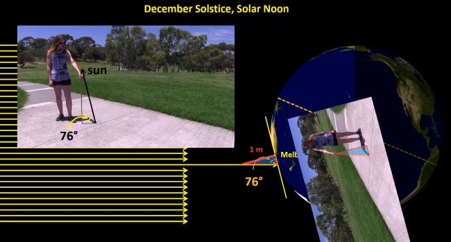
When the sun reaches its highest point in the sky, on the day of the summer solstice here in Melbourne, it’s at an angle of about 76° above the horizon. The 1 metre ruler casts a shadow that’s only about 26 cm long.
We can compare real life with the diagram again. In real life the sun is at an angle, as shown by the shadow, of 76° above the horizon and it’s exactly the same angle in the diagram! Once again, rather than letting you do all the mental gymnastics of comparing the photo with the diagram, I can turn the photo and flip it around so that you can see that the photo and the diagram are showing exactly the same situation. The two triangles are the same again.

So, depending on the time of year, the angle of the sun above the horizon at solar noon is different. Let’s actually look at what happens throughout the year.
In Melbourne, in the middle of the day of the summer solstice, the shadow of a 1 metre ruler is 0.26 metres long because the sun is high in the sky at an angle of 76° above the horizon.
At solar noon on January 21, the sun is at an angle of about 72° above the horizon and the shadow of a vertical 1m ruler is 0.32 m long.
The highest angle that the sun reaches in the middle of the day changes as we move through February, March, April, May, and June and as we’ve seen, the sun doesn’t get very high on the day of the June solstice. After June, the sun rises to a higher and higher angle as we move through July, August, September, October, November, and back to December.
We aimed to capture these images monthly on around the 21st of every month, to coincide with the December and June solstices, but sometimes it was cloudy. We also tried to use the same camera position every month but though we didn’t exactly nail it, the changing angle of the sun is still pretty obvious.
Now these angles are for Melbourne and for all locations on Earth that have the same latitude as Melbourne which is 38°S. The angles for locations 38°N are also the same, but the highest elevation angle that the Sun appears to reach occurs in June in the Northern Hemisphere and the lowest elevation angle occurs in December.
 At different latitudes, the highest elevation of the Sun at different times of the year is different to those of Melbourne’s. If this is the Earth’s orientation on the December solstice, we can see that if you’re standing on the Tropic of Capricorn at solar noon, the Sun is directly overhead. Its elevation is 90°. On the equator, at 0° latitude, the elevation is only about 67° at solar noon. It’s actually 66.6° which is 23.4° less than 90°. The value of 23.4° is the difference in latitude between the Tropic of Capricorn and the equator. If you’re on the Tropic of Cancer at solar noon on the December solstice, the sun reaches its highest angle of about 43° (actually 43.2°, which is 90° – 23.4° – 23.4°). If you’re at 52° North (which is about the latitude of London, England), the sun reaches an elevation of only about 15° above the horizon, which is obviously not very high.
Now if we go back to Melbourne’s Sun elevations we can see that the highest elevation angle it reaches is 76 degrees and that its lowest is 29 degrees. The difference is 47 degrees. This is about double 23.4 degrees, which is the tilt of the Earth with respect to the orbital plane!! This isn’t a co-incidence!! The Northern Hemisphere tilts away from the Sun in December and towards the Sun in June. The tilt doesn’t change as far as the whole universe is concerned, but as far as the Sun is concerned, you can think of the Northern Hemisphere of the Earth as facing away by 23.4 degrees in December and towards the Earth by 23.4 degrees in June, so the total CHANGE that the Sun sees is double that, which is about 47 degrees. What WE see, is a total change in the angle of the Sun between summer and winter at solar noon of 47 degrees.
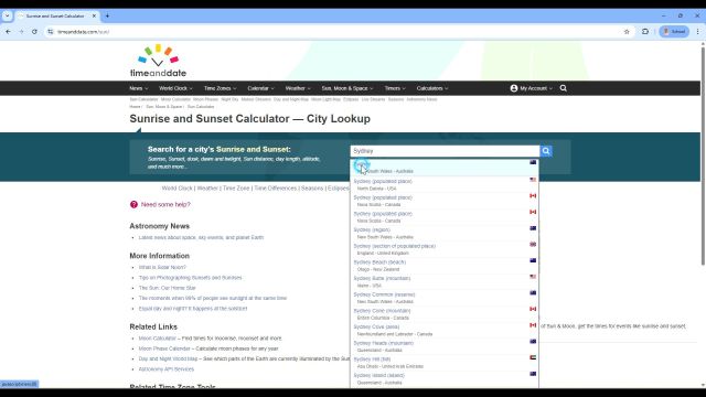

So how can you get data about Sun angles in different parts of the world? Well, if you go to the timeanddate.com website, hover over the Sun, Moon, and Space tab, click Sun calculator, type in and select a location, like Sydney, Australia, and then scroll down, you’ll get to a table that includes the local time that solar noon occurs on any day that you want and the highest elevation that the Sun reaches on that day. On December the first, solar noon occurred in Sydney at 12:44 pm and the Sun was at an elevation angle of 78.0°.
Thanks for watching. See you in the next episode, where we’ll be taking a deeper dive into how the Sun’s path changes throughout the year. Bye for now.
CREDITS
Produced by Liacos Educational Media
Opening and end titles music by Humanoide_Media via Pixabay.
https://pixabay.com/users/12661853/?tab=music&order=latest&pagi=1
https://pixabay.com/music/main-title-star-wars-style-march-165111/
https://pixabay.com/music/main-title-invasion-march-star-wars-style-cinematic-music-219585/
Star-Wars-style opening crawl generated at the STAR WARS Intro Generator website. https://starwarsintrogenerator.com/
Visit the timeanddate.com website for all the Sun-related data that you need! https://www.timeanddate.com
Sections of this video first appeared in Shedding Light on the Sun and Earth Episode 3: Following the Sun