


What do azimuth and altitude mean?
How does the Sun’s azimuth change throughout the day?
How does the Sun’s altitude change throughout the day?
Why do the hands on clocks turn clockwise?
A 2-minute excerpt followed by a 45-second trailer.
The STAR LAWS Episode X Question Sheets for Students:
 Question Sheet 10A: Reading Sun-Path Diagrams.
![]() QS10A PDF version.
QS10A PDF version. ![]()
Google QS10A Google Doc version. Google
![]() QS10A Microsoft Word version.
QS10A Microsoft Word version.![]()
Question Sheet 10B: Creating Sun-Path Diagrams.
![]() QS6B PDF version.
QS6B PDF version. ![]()
![]() QS6B Microsoft Word version.
QS6B Microsoft Word version.![]()
![]() If you have ClickView, watch the whole episode here.
If you have ClickView, watch the whole episode here.
The Transcript:


The word astronomy comes from the Greek words astron which means star and nomos which means law. Astron nomy therefore translates literally as STAR LAWS. Astronomy is the study of the laws of nature that govern how stars and other bodies in space appear to move across the sky, how they form, and how they change over time.
In this episode, we’re going to look at how the Sun’s position in the sky can be described by its altitude and its azimuth…
Hi Everyone, it’s Spiro here. In this lesson, we’re going to continue to learn about how the Sun’s path across the sky changes throughout the year, but I’m going to bring in more figures, because quite often you can’t fully understand something until you can measure it.
So, which direction do I have to look in to see the Sun? Well, to fully express where the sun is right now from my point of view, I need to give you two bits of information: the sun’s altitude, which is also known as its elevation, and its azimuth, so that’s what we’ll be covering in this lesson.
We’re also going to look at sun-path diagrams, which show in 2D where the Sun is at any given moment of a particular day and at a few simulations.
Let me begin by explaining what the Sun’s altitude and azimuth are!
 The sun’s altitude (or elevation) is the angle of the sun above the horizon. We’ve already looked at this concept. At sunrise, the Sun’s altitude is basically zero degrees. As it rises, its altitude increases until it gets to its maximum angle at solar noon, and then its altitude decreases until sunset when it reaches zero degrees again.

The Sun’s azimuth at any given moment is the horizontal angle of the Sun, measured in degrees, around from North. Now that pier behind me, which you can also see on Google Maps, is directly north of where I’m standing. You can see that my shadow is pointing in that direction so the Sun must be shining on me from that direction. The Sun’s azimuth angle right now (it’s mid-morning), is about 65 degrees.
It’s now solar noon and my shadow is pointing directly southwards. The Sun’s azimuth angle is 0 degrees. It’s directly north of me.
And now, in the afternoon, my shadow is pointing in that direction and the Sun is over in that direction. It’s at an azimuth angle of about 298 degrees.
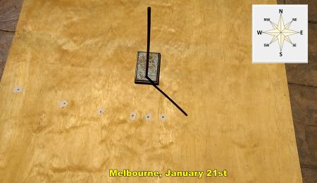 Now if you’ve seen previous episodes, you will have seen this timelapse that effectively shows the path of the Sun by the movement of the shadow of the retort stand. This timelapse was shot in Melbourne, on January 21st, basically in the middle of the Australian summer.
I can actually simulate the movement of the sun on this day using this amazing simulation at andrewmarsh.com (https://andrewmarsh.com/apps/staging/sunpath3d.html). The red line shows the Sun’s path on this day.

I’ve found Karkarook Park on Open Street Map, I’ve put in the date, the 21st of January, and I’ve selected Sun Position, Sun Direction (the blue arrow), Sun Angles (which are the azimuth and altitude angles), Shadows (which I think helps with the visualization, The Path Line for the Current Day and the Base Axis. For the time being, I’m going to leave Annual Area and Annual Lines off.
We can see that at 10 am the Sun’s azimuth is about 84 degrees around from north and its altitude is about 41 degrees above the horizon.
If I hit play, Andrew Marsh’s simulation simulates the Sun’s path. In the morning, the Sun’s altitude increases of course and it moves around more and more towards the North. If I stop it here, for example, we can see that at 11:45 the Sun’s azimuth angle is about 59 degrees around from north and its altitude angle is about 61 degrees.
Until solar noon, the Sun’s altitude angle continues to increase and the azimuth angle gets closer and closer to zero degrees, that is, directly north.
After solar noon, the Sun’s altitude starts to decrease as it moves into the western sky and its azimuth moves into the 300’s (or in the negatives). If I stop it here, we can see that at 14:59, that is, 2:59 pm, the Sun’s azimuth is about -53 degrees which is the same as 360 – 53 degrees which is 307 degrees and its altitude is about 64 degrees.

So here on the left we have a table showing the azimuth and altitude angles of the Sun at every hour throughout the day of January 21 in Melbourne. We can actually represent the 3-D movement of the Sun across the sky in 2-D using what’s called a sun-path diagram or an altitude-azimuth (Alt-Az) graph. For an observer standing in the centre here, it plots the Sun’s position in the sky for that observer by using the radial lines (here coloured blue) to represent azimuth and the concentric circles (here coloured red) to represent altitude. These kinds of diagrams are used heavily in astronomy, architecture, and solar-energy installations.
For example, we can see that at 6:20 am the Sun rose at an azimuth of about 116 degrees on this day. We can also see that at 10 am, the Sun’s azimuth was 84 degrees. Azimuth is kind of intuitive on the flat screen you’re watching this on because azimuth is horizontal direction. The sun is shining on the observer from this direction. To represent altitude, you read off the circles. At 10 am the sun had an altitude of about 41 degrees. 10, 20, 30, 40 41 degrees. Altitude is not so intuitive on a Sun-path diagram, but basically, the closer to the centre the dot is, the higher in the sky the Sun is.
So, let’s collect some data.
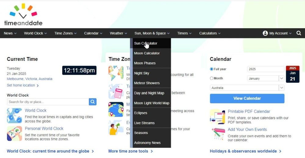

If you go to the timeanddate website, hover over the Sun, Moon, and Space tab, click Sun Calculator, and then type in your city or town, which for me is Melbourne, Victoria, Australia (or click the suggestion if it comes up), you can see where the sun is in real time. As I did this screen capture, the sun had a direction (that is an azimuth) of just under 43 degrees around from north and an altitude of just over 67 degrees above the horizon. It also gives other information like, for example, how long daylight will last, sunrise and sunset times, and the sun’s azimuth angles at sunrise and sunset.
It also gives other information like, for example, how long daylight will last and sunrise and sunset times.

If you scroll down, you can get information, let me zoom in a little again, about the sun’s position, (Altitude and Heading, which technically is called azimuth or horizontal direction) to the nearest degree throughout the day for any day you want.
If you click and hold on the graph, you can scroll across to see the Sun’s position at different times of the day. The advantage of using timeanddate.com to collect data is that it automatically adjusts for daylight saving time.
So, for example, on January 21, in Melbourne, which is today for me as I record this voice over, but which is in the past for you if you’re watching this, the Sun’s altitude at 12 o’clock was 63 degrees above the horizon, while its azimuth (which timeanddate.com calls heading) was 54 degrees, kind of north-easterly. If I move over to 6 pm, the Sun’s altitude was 30 degrees above the horizon, while its azimuth was 267 degrees (which is almost directly west; west is 270 degrees).

Now getting back to Andrew Marsh’s simulation, if I click Annual Lines and Annual Area, I see not just the Sun’s path for a given day but also the range of paths that the Sun takes across the year. This path is the path that the Sun takes on the day of the December solstice, the path highlighted in red is the path taken at the equinoxes (notice I’ve set the 20th of March as the featured date), and this low path is the path that it takes on the day of the June solstice. You can see clearly that the Summer Sun gets to a much higher angle in the sky than the winter Sun does.
In the Southern Hemisphere, the Sun appears to move across the sky in an anticlockwise path and is generally towards the north of where you are, that is, it’s usually in the northern part of the sky. Notice the N for north there. In the Northern Hemisphere, the Sun appears to move clockwise and is generally towards the south of where you are or in other words, it’s usually in the southern part of the sky. The reason for the difference is that Southern Hemisphere observers are upside down compared to Northern Hemisphere observers.
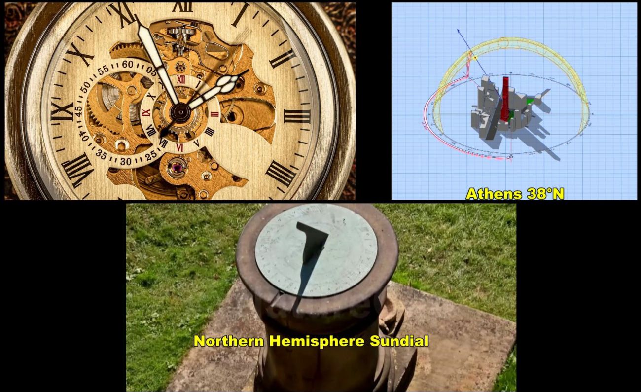
Now the reason that clocks move clockwise, is that early clock makers who all lived in the Northern Hemisphere, wanted the hands of the clock to move in the same way as the Sun did and therefore also the same way that shadows on sundials did: clockwise.
Thanks for watching, see you next time.
CREDITS:
Produced by Liacos Educational Media
Screen recordings taken from the andrewmarsh.com website at
https://andrewmarsh.com/apps/staging/sunpath3d.html
and from the timeanddate.com website at
Also check out https://andrewmarsh.com/apps/releases/sunpath2d.html
Opening and end titles music by Humanoide_Media via Pixabay.
https://pixabay.com/users/12661853/?tab=music&order=latest&pagi=1
https://pixabay.com/music/main-title-star-wars-style-march-165111/
https://pixabay.com/music/main-title-invasion-march-star-wars-style-cinematic-music-219585/
Star-Wars-style opening crawl generated at the STAR WARS Intro Generator website. https://starwarsintrogenerator.com/